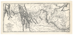
A map of Lewis and Clark's track across the Western portion of North America from the Mississippi to the Pacific Ocean: By Order of the Executive of the United States in 1804, 5 & 6
A map of Lewis and Clark's track across the Western portion of North America from the Mississippi to the Pacific Ocean: By Order of the Executive of the United States in 1804, 5 & 6
Facsimile map depicting Lewis And Clark's trek across Western North America (1804-1806). Map is a copy by Lewis of a map by Clark and includes notations about indigenous territory as well as population numbers for various tribes. Several rivers are labelled with the indigenous names.